The HTM-NET network stations18 of these are currently deployed between Menton and Cap Couronne. They are fitted with pressure sensors, one above water and the other underwater, which are used to acquire long-term data on variations in atmospheric pressure and water pressure every 2 minutes. The water level is then calculated from this pressure data.
Surprising as it may seem, although the Tonga Islands are located around 17,000 km from France, variations in atmospheric pressure associated with the event have been detected by weather stations. Julien Lefèvre (INT, AMU), who works with the EcoInfo Didier Mallarino (our network data manager), who had already worked with us on network data, who contacted Didier shortly after the event to tell him that the network's atmospheric sensors had recorded pressure variations!
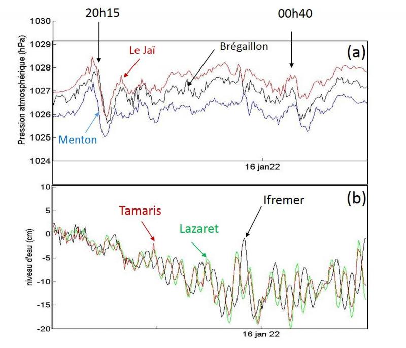
The eruption of the Hunga volcano on 15/01/2022 generated an atmospheric shock wave that propagated around the Earth at a speed of around 1200 km/h. A first wave from the north, with an amplitude of around 150 Pa, was detected by the stations' atmospheric sensors at around 20:15 UTC, followed by another, more attenuated wave from Africa around 4 hours later (see Figure a).
These spatio-temporal changes in atmospheric pressure have generated "meteo-tsunamis" which, through resonance phenomena, can be amplified in semi-open basins such as bays or harbours. Figure b shows marked oscillations in the water level in Toulon's small harbour. Note that oscillations of lesser amplitude were also observed at the other HTM-NET stations.
Analyses of this exceptional phenomenon are underway at the Laboratory and in collaboration with the CEA, in charge of the CENALT tsunami warning centre, in partnership with the Shom and the CNRS.
Thanks again to Didier Mallarino, Tathy Missamou, Technical Manager, and Jean-Luc Fuda, who works with Tathy on the installation, calibration and maintenance of the HTM-NET stations, for their involvement in the network.


